
DAY HIKES
Day hikes are great options if you want to see nature highlights in Kuusamo, Salla, Posio and Hossa
DAY HIKES IN KUUSAMO, SALLA, POSIO AND HOSSA
Join us on day hike - we offer a variety of different routes ranging from 4 to 20 kilometers. Although the short hikes are called day trips, we are also organizing a few trips as evening trips and enjoy a bright, long summer evening! Unless otherwise stated, all our tours starts and ends in Ruka and transportation is included.
All tours include picnic lunches and hot drinks in the heart of nature - you can focus on enjoying the authentic hiking atmosphere!
Participating in a hiking trip does not require previous camping experience and normal good basic fitness is sufficient. Our pace is peaceful, so you can focus enjoying the enchanting nature and eye-catching landscapes.
We are organizing these day hikes in a small group including max 6 persons. We always respect the nature and use existing trails to minimize our impact.
If you can't find an day hike at the time you want or you want to combine several day hikes with overnight stays, we are happy to prepare a vacation based on your preferences, so please contact us!
Please note that we also make trips to other destinations in the region - let us know your wishes and we will make them come true!
OULANKA NATIONAL PARK AND VALTAVAARA - PYHÄVAARA DAY HIKES
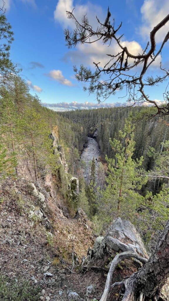
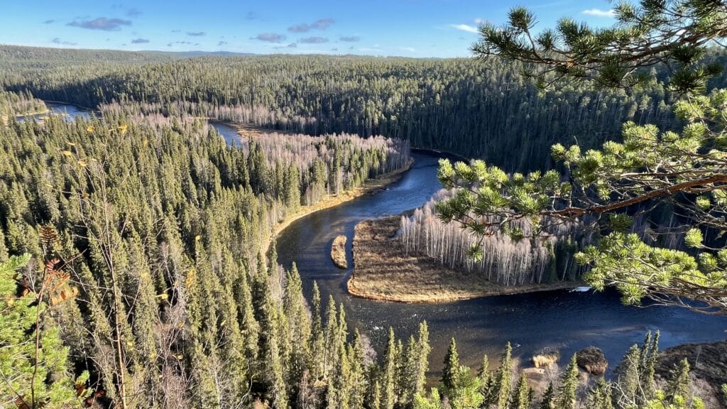
Oulanka Canyon route is in the Salla, The route is an approx. 6 kilometer long cycle route offering stunning scenery. The route is classified as demanding due to its large differences in height.
The duration of the day hike is 3-4 hours + transportation 2 hours.
At the beginning of the route, you travel outside the national park which is typical Finnish forest Inside the park, the first destination is Kirkasvetinenlampi. The name means clear water pond and like name describes, it has really clear water on it. There is a cozy fire place by the pond, where we can take a breather and admire the scenery.
We continue hiking along the lakeside grove, after which we climb to a high ridge, from where you can still admire Kirkasvatinenlampi pond. From the other side of the ridge, you can already hear the sound of the Oulanka river.
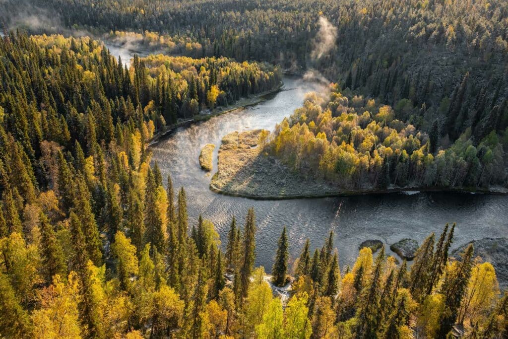
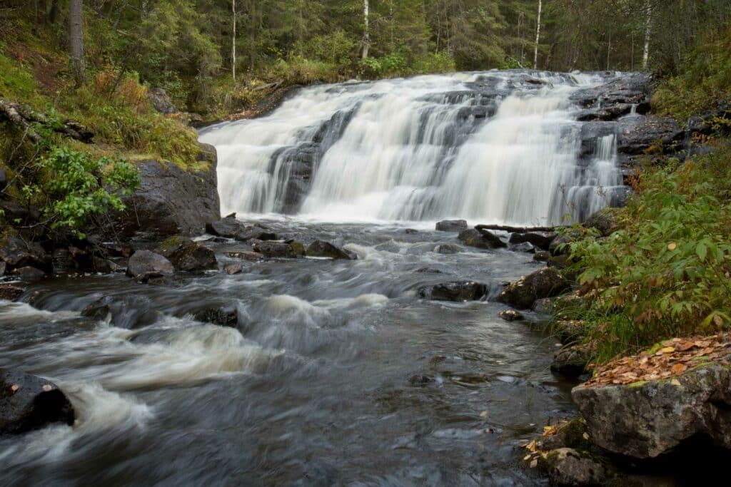
The first viewing point for Oulanka Canyon is Oulanganköngäs rapids.. After that, we hike in the forest for a while before we reach the best viewpoint of the route, Pikkuköngäs rapids. From here, the most spectacular views of the route open up to the Oulanka Canyon, which is one of the most spectacular sights of the national park.
From the edge of the canyon, we descend to Savilampi wilderness hut, where we have a hot drinks and snack break. While preparing the hot drinks on open fire, you can cross the Oulanka River to the suspension bridge and admire the views of the canyon from the other side of the river.
After the break, we continue along the Karhunkierros route for just under a kilometer near Savilampi shore before we head towards the parking lot and the transportation back to Ruka.
Keroharju kuiskaus is a 17-kilometer long route. The route is classified as medium difficulty. We take the route from the direction of Salla towards Kuusamo.
The duration of the trip is 8 - 10 hours + transportation.
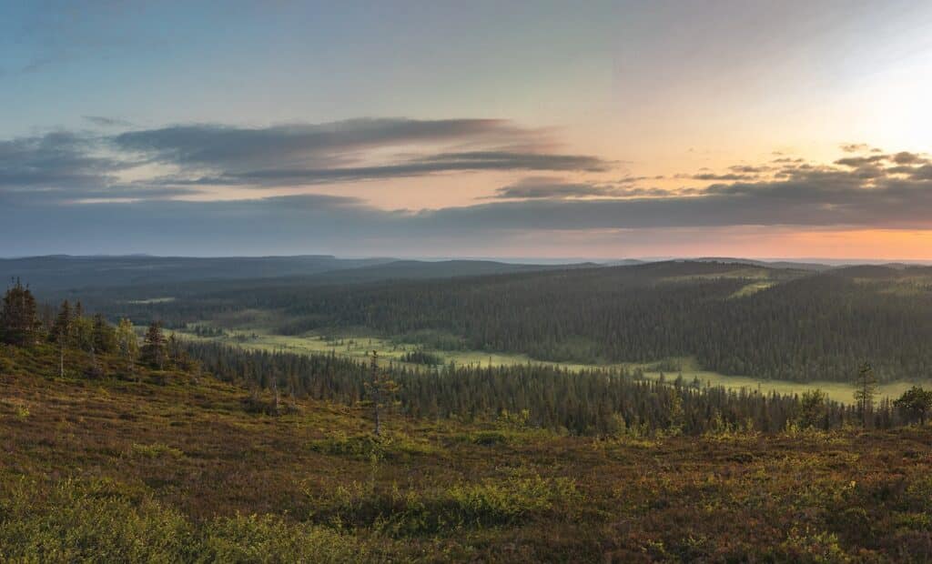
The route runs in the northeastern part of Oulanka National Park and it is significantly calmer than other routes in Oulanka National Park.
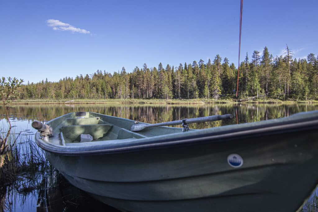
At the beginning of the route, we cross Niihtelysjoki by rowing a cable boat. After crossing the river, we travel along a ridge and canvas terrain, so the terrain is hard-bottomed and therefore quite easy to hike.
After three kilometers, we take a breathe at the Elijoki shelter. From the shelter, we continue hiking along the ridge and across the marshes towards Kerojärvi and its wilderness hut, where we have a lunch break. On this part of the route, we can admire the beauty of the open fields and rivulets and possibly see cranes, woodcocks and grouse, among others.
After the Kerojärvi wilderness hut, the route continues along the narrow Keroharju and diverges at the bank of Karvastekemäoja. On the way there is also the Kirkonnurkanlampi shelter, where we take a short break before hiking to the end point in Harjulammentie.
We can also do this trip as an overnight trip, where we stay near the Kerojärvi wilderness hut and enjoy sauna in the peace of the wilderness! Ask more using the contact form or see here
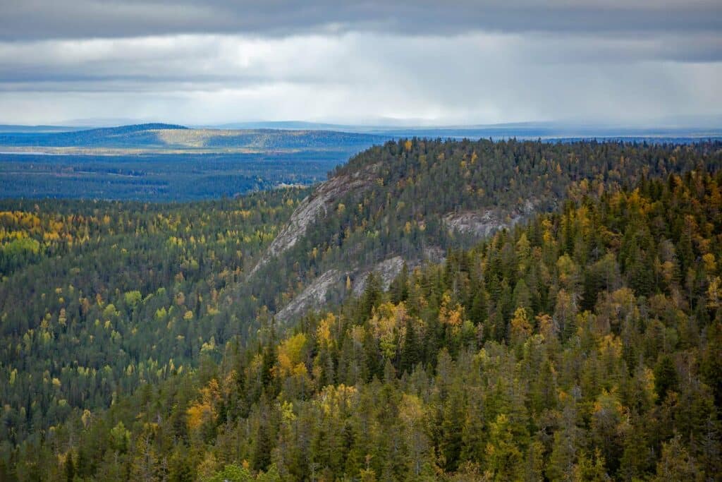
Ruka - Valtavaara - Konttainen is about 9 kilometers long, a challenging route due to differences in height and difficult terrain in some places.
The duration of the trip is about 5 hours, including transportation back to Ruka
We start the route from Itä-Ruka, from the Saarua parking lot. At the beginning of the route, we hike up towards Valtavaara. On the way, we walk along paths and stairs in the middle of untouched primeval forest. At the beginning of the route, we see our first destination, the peak of Valtavaara, where there is still plenty to climb.
The first resting place on our way up is the rest stop at Valtavaaralammi, where we gather our strength for a moment before the last ascent to Valtavaara. From the top of the thill, we can admire stunning landscapes. At the top of Valtavaara, we enjoy hot drinks and a small snack before we head towards Konttaneni, which we can see in front of us.
From the day hut in Valtavaara peak, we hike along the Valtavaara, descending steep paths and stairs towards Konttainen. At Suolampi shelter, we take a short break before the last descent to Virkkulantie and the Konttainen parking lot.
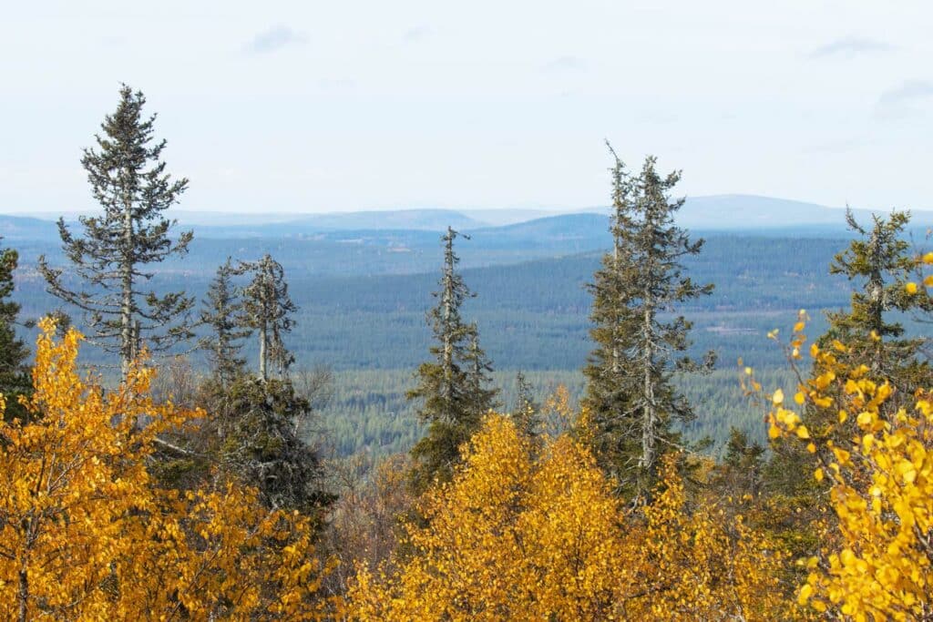
From the parking lot, we climb to the top of Konttainen to admire the magnificent scenery offered by the open rock. The climb to the top is steep, but fortunately short, and the views from the top reward the effort!
After admiring the scenery, we descend back to the parking lot, from where we are transported back to Ruka.
Pähkanänkallio is a conservation area of Oulanga National Park, so it is forbidden to hike in the area from April 1st to August 15th. The area has been restricted due to peregrine falcon nesting.
Length of the route is approx. 4 kilometers, but due to the differences in height, the route is demanding, even though the terrain is otherwise easy to walk.
Pähkanänkallio offers perhaps the most photographed landscapes of Oulanka National Park…
We leave the parking lot at the end of Päähkänänkalliontie and dive straight into the forest of the national park area. After walking a kilometer, we are already at Pähkänänkallio, from where we can admire the scenery of Oulankajoki in its all beauty. The eye rests while looking at the slowly flowing Oulankajoki. Later in the autumn, it is great spot for viewing the autumn colors in full scale, but the view that opens up from the top is always incredibly enchanting sight.
From the cliff, we go down to the shelter next to the river, where we make hot drinks on open fire before returning back to the parking lot.
Posio AND RIISITUNTURI NATIONAL PARK
Riisin rietas -route is the longest route in Riisitunturi which starts and ends from the same location. The route is approx. 11 kilometers long and classified as medium/difficult.
The duration of the trip is 5-6 hours + transportation.
The route goes through fell peaks, slopes and forests. We first hike up to Riisitunturi, where we take our first break and admire the view from the top of the fell to the fell, lake and forest landscape.
From the top of the hill we descend towards Uusilampi and Uusisuo, which we cross along the duckboards. After the swamp, we follow the Riisisuo and walk along the slope of Nuolivaara. Before crossing Riisisuo, we see, an old sacrifice place.
We cross the Riisisuo along the duckboard and see, among other things, an old meadow barn that stands alone in the swamp.
From the swamp, we ascend towards Soilu shelter, where we prepare hot drinks on the open fire and eat our picnic lunch.
After the break, we climb to the top of Riisitunturi and visit the elongated Ikkunalampi. From Ikkunalampi, we continue towards the parking lot and return to Ruka.
The ribbon-like hiking trail that goes through the Korouoma nature reserve is about 20 kilometers long and is moderately demanding
This hike is an overnight hike, which basically means 1,5 days - starting at 9 AM on the morning and ending on next day around 2 PM.
We start the route near the center of Posio. A more detailed schedule and place of departure will be announced upon confirmation of registration.
We start hiking from the parking lot of Lapiosalmi, from where we proceed along the shores of clear lakes to Kuulea shelter where we will make short stop.
After the break, we continue hiking in the terrain of the lake shore until we reach the Korouoma nature reserve. We take a lunch break on the Koron Latvajärvi shelter and admire the majestic lake scenery.
After lunch, following the shores of Latvajärvi, Koivulampi and Korojoki and enjoying the views, we hike towards the camp place, Pajupuro wilderness hut. We set up our camp close to the hut. In the evening, we go over the day's experiences and familiarize ourselves with the next day's route.
In the morning we set off and follow Korojoki. At the same time, we wnjoy the views of the gorge valley, steep cliffs, waterfalls and the breathtakingly beautiful landscape.
We will step to see the sights of Piippukallio before we arrive at the Saukkolampi parking lot.. From there we have transportation back to the starting point of the hike
We can also do this trip as a day trip! Ask more using the contact form!
Salla NATIONAL PARK
The Pahakuru circuit route is approximately 18 kilometers long and is moderately difficult.
The duration of the excursion is 7-8 hours. We start from Salla Ski Resort (Revontulentie 7, Salla), but it is also possible to include transport from Ruka to the starting point. The duration of the transport is one hour / direction.
The Pahakuru hiking route presents almost all of the finest sites in the Salla national park. Along the route, we can admire, among other things, old forests, grey pines and moss-covered spruces.
There are several streams, marshes and ponds along the route as well as fell landscapes. The northern Sallatunturi, the highest point of the national park, can be seen from several different directions, and the Russian side's large hills are also visible in the landscape.
The route is crowned by the Pahakuru shelter and its old pine trees, the rocky gorge and the slopes of Aatsingihauta hill, which peek out from the trees.
The route gives the feeling of a real wilderness, which you can enjoy with us. We take breaks on the way as needed, but we eat our picnic lunch at the Pahakuru. Pahakuru is the steepest gorge in the whole park and the really is an impressive place.
At the end of the route, we take a short stop at Tunturilampi shelter, which opens up very photogenic landscapes of the fell terrain.
Please note that we also do a two-night hike to Salla National Park, which combines the routes of Aihkipetsi, Ruuhitunturi and Pahakuru into one hike. If you are interested in this hike, please contact us via the contact form.
CONTACT US!
Do you have any questions? If yes, please fill in the form and we will get back to you as soon as possible. You can also send us an email to info@oulangantaika.fi or WhatsApp us in +358405900001.

